 Sustainable Woodstock
Woodstock Safe Routes
This page sets out more detailed
proposals for Sustainable Woodstock’s Safer Routes Projects and includes
road safety issues related to walking, cycling and the general
well-being of the community.
The Problem:-
.jpg)
The
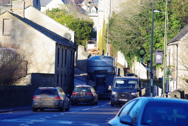
narrow pavements and carriageway Old Woodstock and at The Black Prince
pub
.jpg) Left:
Narrow pavements and carriageway at The Causeway Right: The A4095 Hanborough to Bladon
Left:
Narrow pavements and carriageway at The Causeway Right: The A4095 Hanborough to Bladon
And this is what can happen without adequate safety protection .....
The A44 carries some
15,000 vpd, (peak hour flow 1200 vph) of which 7% are HGVs. The
carriageway is:-
- sub-standard in terms of width being only
5.5 m in places and insufficient for two HGVs to pass safely
- footways are also substandard in width
being less than 0.75 metres in places (a child’s pushchair is 0.66m
wide).
- The building line is frequently at the
immediate back of the footway offering pedestrians no opportunity to
step back behind the path for safety
- The horizontal alignment is tortuous such
that opposing traffic is often blind, leading to vehicles travelling
closer to kerbs than might otherwise be normal.
- the road is on a gradient (approx 1:12)
sometimes encouraging excess speeds for downhill traffic
The average vehicle speeds vary from under 30
mph in the town centre area to about 32 mph on the hills.
For residents in Old Woodstock in particular there is no alternative route to the schools and the town centre other than to use the A44.
So what is Sustainable Woodstock doing ....
The Woodstock Safe Routes Project has joined
forces with other campaigners across Oxfordshire for a default 20 mph
speed limit in all residential streets and shopping areas. Read
more here including the groups first press release ....
The new Fair Deal Alliance at Oxfordshire County Council is a Lib Dem,
Labour and Green coalition and have already committed to rolling out 20
mph speed limits across Oxfordshire to all communities that request it.
Woodstock has submitted its bid but as the roll out will be
spread over several years, Sustainable Woodstock is anxious to apply the
maximum campaigning pressure to ensure that our demands are met at the
earliest opportunity. There
can be few communities with the same severe traffic problems that
Woodstock experiences with its busy A44 road.
 We
believe that the case for a targeted 20 mph speed limit over a
critically limited length of the A44 is strong and the opportunity that
the government’s statutory guidance offers will allow a temporary
Traffic Regulation Order to be drawn up with suitable lines and signs at
low cost.
We
believe that the case for a targeted 20 mph speed limit over a
critically limited length of the A44 is strong and the opportunity that
the government’s statutory guidance offers will allow a temporary
Traffic Regulation Order to be drawn up with suitable lines and signs at
low cost.
Supplementary Measures required include the
following:-
1. Reduction of the current 50 mph speed
limit on the A44 between the Bladon Roundabout and the present 30 mph
limit. This 50 mph limit should be reduced to either 40 or 30 mph
2. Likewise, north of the town, the present
50 mph limit should be reduced between Hill Rise and the first Wootton
turning (Stratford Lane) to 40 mph. This would particularly
support cyclists to and from Wootton and other destinations, as there is
no segregated cycle path on this fast stretch of carriageway.
Additional cycle racks in the town centre are
also required the location of which should be agreed with the Town
Council
You can read the full
submission to Oxfordshire County Council here and a similar
proposal has also been submitted in respect of the A4095
through Bladon.
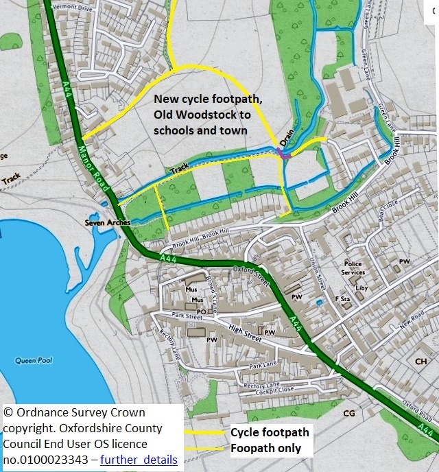 We
are also campaigning for a new Off Road cycle footpath from the north of
the Woodstock (Old Woodstock) to the town centre and to the schools.
Working with Blenheim Estates we have come up with a plan that provides
an off road link from the proposed new development at the back of Hill
Rise across the new woodland area planted by Blenheim and crossing the
River Glyme millstream on a simple timber bridge close to where the
river and millstream separate. It will then link into the public
road network in Glyme Close and thence via safe and quiet roads to the
town centre, the schools, the surgery, the swimming pool and all of
Woodstock's services.
We
are also campaigning for a new Off Road cycle footpath from the north of
the Woodstock (Old Woodstock) to the town centre and to the schools.
Working with Blenheim Estates we have come up with a plan that provides
an off road link from the proposed new development at the back of Hill
Rise across the new woodland area planted by Blenheim and crossing the
River Glyme millstream on a simple timber bridge close to where the
river and millstream separate. It will then link into the public
road network in Glyme Close and thence via safe and quiet roads to the
town centre, the schools, the surgery, the swimming pool and all of
Woodstock's services.
See a plan and further details of our suggested off highway alternative routes from Old Woodstock to the town centre and to the schools here.
Traffic Management
But it’s not just about building new cycle footways and better cycle
access through Blenheim Park.
Measures are need to better control and manage traffic throughout
Woodstock and the neighbouring villages.
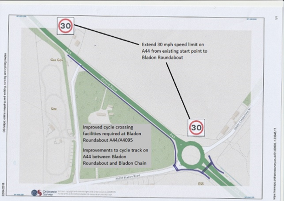
We need to provide an extension of the 30 mph speed limit on the A44
from the A4095 Bladon to the present point at which the speed limit
starts. We also need to
have the existing cycle footway from the roundabout to Bladon Chain
widened and improved, including safer crossing points at the roundabout.
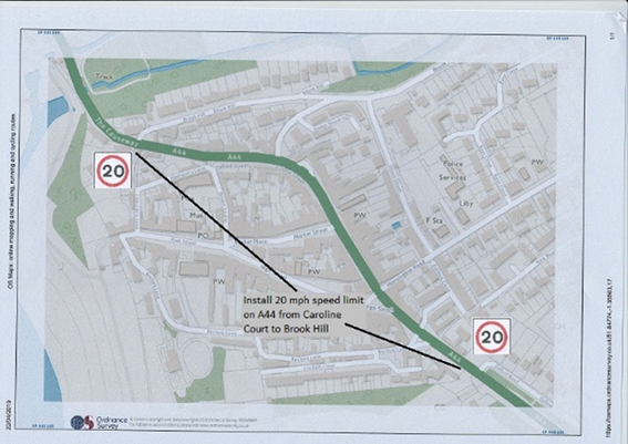
 We need a 20 mph speed limit on the A44 in Woodstock Town Centre and it
is suggested that it should run from Caroline Court at least to Lower
Brook Hill. A further section
within Old Woodstock should also be considered. The extent
of the limit is open to further
discussion.
We need a 20 mph speed limit on the A44 in Woodstock Town Centre and it
is suggested that it should run from Caroline Court at least to Lower
Brook Hill. A further section
within Old Woodstock should also be considered. The extent
of the limit is open to further
discussion.
 We also need to have the 30 mph on the A44 extended at the northern end
of town to incorporate the new access to the proposed Hill Rise
development.
We also need to have the 30 mph on the A44 extended at the northern end
of town to incorporate the new access to the proposed Hill Rise
development.
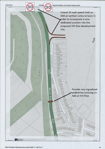 And we need to have new and improved signalised pedestrian crossings at
these locations:-
And we need to have new and improved signalised pedestrian crossings at
these locations:-
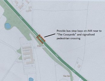
-
On the A44 at “The Cowyards” to accommodate a new bus stopping point
and bus bay for the new Park View development at Woodstock
South-East.
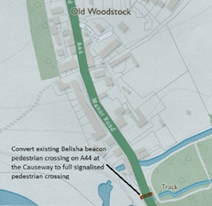
-
The upgrading of the exisiting Belisha beacon crossing on the A44 at
The Causeway to a full signalised pedestrian crossing
-
A new signalised pedestrian crossing at Hill Rise fo access to the
proposed new cycle footway witin Blenheim Park
See also our page of FAQs on Speed Limits, One-Way streets and HGV Weight Limits
Longer term, Woodstock Safer Routes campaign
also seeks a
safe pedestrian/cycle route connecting Woodstock to Wootton,
Stonesfield and Charlbury through the provision of a segregated
cycle/footway alongside the A44 from Hill Rise to the junction with the
B4437 at Judds Garage.
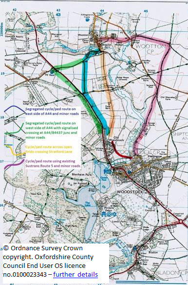
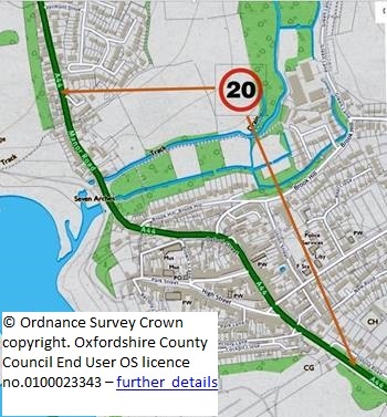
There are four possibilities:-
-
The Orange route. This
follows the line of the existing public right of way on foot
(footpath) from the proposed Old Woodstock development site, direct
to Wootton.
-
The Green route. This uses
the existing pavement (footway) on the west side of the A44.
It will need substantial improvement to be a viable
cycle/footway. It will need
to proceed as far as the junction with the B4437 (at The Duke of
Marlborough pub) because a crossing at the first Wootton turn is too
dangerous. A signalised
crossing at the B4437 junction is possible and would provide
additional road safety at this junction with a long accident
history.
-
The Pink route follows the existing Sustrans National Cycle Network
Route No. 5. It would then
need to turn onto an existing bridleway to Milford Bridge and on the
Wootton.
The prefered proposal at present is for a combination of the blue and
green routes using segregated cycle footways on both sides of the busy
A44 north of Woodstock from Hill Rise to the 1st Wootton
turning. From there to the
B4437 (Duke of Marlborough pub and Judds Garage) the cycle footway would
continue on the west side only.
Access to Wootton from the 1st Wootton turn would be
by the existing minor road network (some traffic management measures may
be needed on the narrow steep hill at West End Wootton).
This proposal is particularly important for the vitality of the Wootton
Primary School that continues to draw pupils from the Old Woodstock
catchment area. An
accessible and sustainable walking and cycling alternative will benefit
familes with students attending both the Wootton Primary School and the
Marlborough secondary school.
© Ordnance Survey Crown copyright. Oxfordshire County Council End User
OS licence no.0100023343